


Coastal Management from Space
Giving Estonia, Latvia, Lithuania and Poland the opportunity to better manage their own coastal resources in an environmental and sustainable way is the aim of a project funded by the European Union (PHARE). The project is based on satellite imaging techniques to map and document sensitive coastline areas of the four countries.
SSC Satellitbild is the lead company of the project consortium, the other members being GOPA of Germany and Kampsax Geoplan of Denmark. The intention is to create an integrated coastal zone management system (ICZM) in all four project countries. Eventually this could form the foundation of a comprehensive data system for the development and management of the entire Baltic Sea region.Transcending borders
"Most environmental issues such as pollution and industrial activities have an impact that transcends national borders", says Jörgen Hartnor, Marketing Manager of SSC Satellitbild. "This is the reason why it is important to give the project countries access to the type of information already available to other countries in the region."
"The project involves bringing together the many national bodies responsible for coastal issues", explains Jörgen Hartnor. They are supported by a team of international experts providing advice on a wide range of topics including environmental issues, pollution, tourism, industrial development, demography and biosciences.
Creating databases
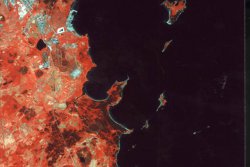
The heart of the project is to create a basic database for ICZM in each of the project countries. Essentially, this task is broken down into three parts. The first is SSC Satellitbild's precision corrected satellite image maps of the region forming the basis of a geographical information system (GIS). "Such maps have been developed with natural resources inventories, land use planning and management in mind", says Jörgen Hartnor.
The second part deals with information related to national and international issues such as environmental legislation, pollution standard limits and fishing regulations. There are also other considerations such as the pressure for coastline development from industry and tourism.
The third part involves creating national centres of expertise responsible for the management and development of the databases after the end of the project. "In this way, continuity is ensured", Jörgen Hartnor says.
"An important step is to define the database components to make them possible to use in all four project countries", explains Jörgen Hartnor.
Operating since 1982, SSC Satellitbild is part of the Earth Observation Division of the Swedish Space Corporation. It is one of the world's leading companies in the field of geographical and environmental information services based on remote sensing satellite data. Its customers include international organisations such as the World Bank, governmental mapping agencies and companies worldwide.
Caption: SSC Satellitbild's precision corrected satellite images have been developed with natural resources inventories, land use planning and management in mind and will be incorporated into the ICZM project.
For further info, please contact:
SSC Satellitbild
Project Leader for the Coastal Zone Management Project: Mr Hans Rasch
e-mail: hcr@ssc.se
fax: +46 8 98 49 75
Project Leader Estonia: Dr Toomas Kokovkin
e-mail: toomas@hiiumaa.ee
fax: +372 46 962 69
Project Leader Latvia: Mr Uldis Kalnietis
e-mail: uldis@novell.varam.gov.lv
fax: +371 782 04 42
Project Leader Lithuania: Dr Gediminas Vaitkus
e-mail: seabird@post.5ci.lt
fax: +370 2 72 92 57
Project Leader Poland: Mr Andrzej Cieslak
e-mail andrzej@flagship.im.gda.pl
fax: +48 58 552 46 13
Press release images
Coastal Management from Space

Feedback is not allowed / disabled for this press release.